Dymaxion Web Mapping
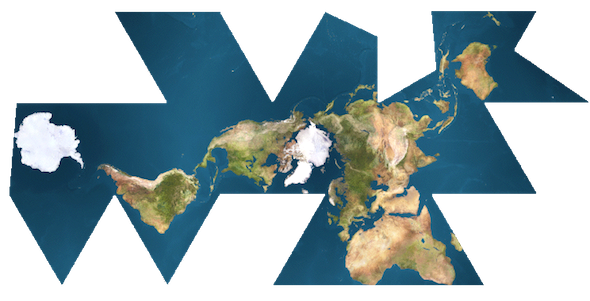
Posted: January 25, 2012 Filed under: Application Programming Interfaces, Web Map Examples | Tags: dymaxion, flash, javascript, openlayers, projections Comments Off on Dymaxion Web MappingR. Buckminster Fuller was truly a modern Renaissance Man. Bucky created many inventions and championed several ideas that have shaped the way we live. One of his creations is the Dymaxion map projection. The map projection is rather complex; the developable surface is an icosahedron. When the icosahedron is then sliced and flattened, it produces a world map that is visually intriguing. It is truly unlike any other map projection.
Though difficult to produce, the code for producing such a projection in a web map is available. Using the OpenLayers JavaScript API and some custom JavaScript from Protovis, Zachary Johnson was able to put together this demo of the Fuller/Dymaxion Projection as the projection for a web map.
In Zachary’s post, he also mentions the Faumaxion web map, which is a Flash-based web map that reorients itself so that north is at the top for any of the triangular faces of the Dymaxion projection. Michal Migurski, a partner at Stamen Design, has the details on how he created the Dymaxion slippy map.
The downside to using a Dymaxion projection in your web map is that the support for the projection amongst the mapping APIs is minimal. You will need to do more of the heavy lifting in order to get this projection working properly in your web map. That’s also ignoring the fact that many people are not spatially aware and that this different projection will require your audience to orient themselves with the way the Earth has been projected. While Spherical Mercator is common and familiar, it does grossly exaggerate the areas closer to the poles, which in turn distorts your mapped data. Choropleth maps depicting a variable dependent on area, such as population density, are often misleading when mapped with a Mercator projection. The Dymaxion map is closer to an equal-area map than most, however the variable orientation towards North makes this projection a hard sell to a general audience.
Nonetheless, the Dymaxion map is an incredible map projection, from both a scientific and aesthetic point of view. The time spent by some very dedicated, intelligent people to get this working in interactive form speaks to the admiration of the projection and its creator. If only Bucky had lived long enough to see what wonders the Internet hath brought…
New to Web Mapping? Get started with Google’s Mapping APIs
Posted: January 24, 2012 Filed under: Application Programming Interfaces | Tags: apis, flash, google, javascript, kml, maps Comments Off on New to Web Mapping? Get started with Google’s Mapping APIsIf you have no experience with web mapping, but have some basic website-building experience, you can begin to make interactive web maps fairly easily using Google’s mapping application programming interfaces (APIs).
Google’s map API page shows you the available APIs for you to use. If you are looking to make maps like those you often see depicting store locations or basic points-on-a-map pages, check out the JavaScript API. There are many tutorials out there to help you get started with mapping, however all of them assume you are familiar with hosting your own web pages. If you’re not sure how to host your own pages, you can still get started with web mapping by using the My Maps functionality of Google Maps.
There are also several other JavaScript-based APIs for mapping, such as OpenLayers, Mapstraction, and ESRI’s JS API. All of these will allow you to embed maps with custom content into your own web pages, however each one has a different learning curve and provide different base maps out of the box.


Recent Comments